i-Boating:Marine Navigation 235.0
Free Version
Publisher Description
i-Boating:Marine Navigation - Chartplotter:Lake depth Maps 4 Fishing,Nautical/Marine Charts w/ Marine Weather
This Marine Charts App offers offline nautical charts, inland river navigation charts, and lake contour maps for fishing,kayaking, yachting & sailing.
First marine navigation app to have boat route assistance with Voice Prompts. All features of a Marine Chart plotter in one app!
It supports Nautical Charts course up orientation. Incl Tide Charts & Currents prediction for nautical navigation.
Create new boat routes / Waypoints, or import existing GPX/KML routes on device. Has Marine AIS(NMEA) support.
►FEATURES
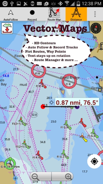
√ GPU accelerated offline vector NOAA charts/ENC charts (text stays upright on rotation)
√ Lake depth map shading/safety lake depth contours:custom boat safety depth
√ Maritime Aids to Boat Navigation : Beacons,Buoys,Boat Launch areas,Boat Ramps,Marina, Fishing Attractors
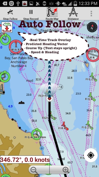
√ Record marine tracks, Autofollow with real-time track overlay
√ Voice Prompts for marine navigation
√ HD 1ft/3ft depth lake contour maps for anglers for selected lake maps: for fishing/trolling(freshwater/saltwater).
√ GPX/KML for boat route.
√ Seamless marine chart quilting: Details from Coastal, Approaches,Harbour & Inland ENC (Electronic Marine Charts)
√ Waypoints
√ Tide & Currents.
√ Marine AIS
√ Anchor Alarm
√ Magnify Text & Icons
√ Wind Prediction Overlay
√ Bearing True/Magnetic
► Fishing Hot Spots AI
► Lake Temperature Maps(Thermoclines accurate to 1°F (0.5° C)
► MAPS
All details of marine chartplotters!
Unlimited updates for 1 year.
USA: Maps incl coverage of NOAA marine charts,ENC,USACE inland river maps & freshwater lake bathymetry maps for more than 50K lakes. Charts incl HD/1ft bathymetry for selected lakes. Incl NOAA marine charts(rasters) w/ NOAA ENC coverage.
Canada:CHS data Incl Great lakes(US & Canada sides),Alberta & Ontario lakes,Lake Simcoe&Trent Severn Canal,Quebec reservoirs.
UK/Ireland: UKHO marine charts
Germany:BSH charts,Waterways & rivers.
France
Europe Inland Rivers:Donau/Danube/Dunaja,Rhine,Rhein,Garonne,Moselle,Drava,Sava
Australia
Netherland/Holland
Croatia
Finland
Norway
Sweden
Brazil
Spain
Malta,Cypress, Mediterranean Sea
Caribbean
New Zealand
Denmark,Greenland,Faroe
Seychelles,Mauritius,Tanzania
Falklands
Malaysia,South China Sea
Persian/Arabian Gulf,Red Sea
South Africa
Argentina
Iceland
Fiji
Estonia,Latvia,Poland,Lithuania
Turkey,Greece,Italy
►Instrumentation
√ Marine AIS & (NMEA AIS and GPS - TCP/UDP)
√ Wind direction & Speed,Marine Sonar depth,Water temperature
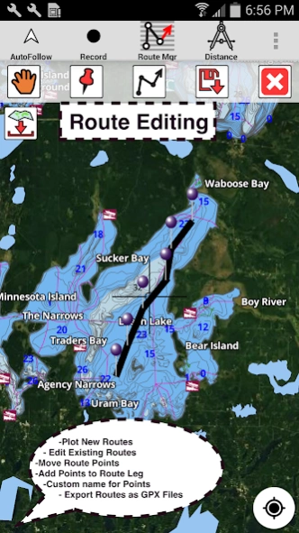
►ROUTE MANAGEMENT/TRIP PLANNING
√ Create/Edit/Reverse Boat Routes
√ Waypoints mgt
√ Import GPX,KML & KMZ files
√ Share/Export Routes,Boating log,Tracks&Markers
►FEATURES for BOAT NAVIGATION
√ Auto Follow
* Real Time Overlay & Predicted Path Vector
* Course Up
* Speed & Heading
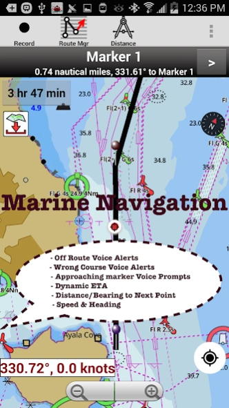
√ Route Assistance With Voice Prompts
* approaching boating route marker prompt
* Real time nautical distance & ETA
* sailing/boating off route/wrong direction
√ Record Tracks
►TIDE & CURRENTS
* High/Low Tides
* Tidal Current Prediction
* Active Current
► SHARING
* Share tracks/Boat routes/markers/Waypoints
* Export GPX files.
► Satellite Imagery
► USA Marine Charts
*Texas Lakes: Texoma,Eufaula,Toledo Bend
*California Lakes:Tahoe,Shasta
Pennsylvania Lakes: Raystown
Florida Lakes: Okeechobee,Kissimmee
*Minnesota Lakes: Minnetonka,Waconia,Leech,Mille Lacs
* Massachussets lakes Quabbin
*Missouri Lakes: Truman
*Ohio Lake maps Lake hoover
*Wisconsin Lakes: Winnebago,Pepin
* Utah Lake Powell,Bear
*Maine Lake Sebago
*Alaska Lakes:Winnipesaukee
*Tennessee Lake Barkley,Norris,Watts Bar
*South Carolina Lake Keowee,Hartwell,Murray
*Lake Michigan,Huron,Ontario,Superior,Erie
► Canada Lakes Maps
* Lac Saint Jean
* Ontario Lake depth maps
* Rideau Canal-Ottawa River
* British Columbia Marine Charts
* Pacific Coast-Vancouver- Haida Gwaii
* Nova Scotia South-Bay of Fundy
* Quebec-Anticosti Island
* Newfoundland
* St. Lawrence river
* Manitoba & Saskatchewan
* Georgian Bay
* Puget Sound
► UK Nautical Charts
* Scotland
* Thames Estuary
* Ireland
► Australia Marine & Lake Maps
* NSW
* Queensland
About i-Boating:Marine Navigation
i-Boating:Marine Navigation is a free app for Android published in the Recreation list of apps, part of Home & Hobby.
The company that develops i-Boating:Marine Navigation is Gps Nautical Charts. The latest version released by its developer is 235.0.
To install i-Boating:Marine Navigation on your Android device, just click the green Continue To App button above to start the installation process. The app is listed on our website since 2024-01-17 and was downloaded 84 times. We have already checked if the download link is safe, however for your own protection we recommend that you scan the downloaded app with your antivirus. Your antivirus may detect the i-Boating:Marine Navigation as malware as malware if the download link to com.skiracer.nautical_astore_lite is broken.
How to install i-Boating:Marine Navigation on your Android device:
- Click on the Continue To App button on our website. This will redirect you to Google Play.
- Once the i-Boating:Marine Navigation is shown in the Google Play listing of your Android device, you can start its download and installation. Tap on the Install button located below the search bar and to the right of the app icon.
- A pop-up window with the permissions required by i-Boating:Marine Navigation will be shown. Click on Accept to continue the process.
- i-Boating:Marine Navigation will be downloaded onto your device, displaying a progress. Once the download completes, the installation will start and you'll get a notification after the installation is finished.
